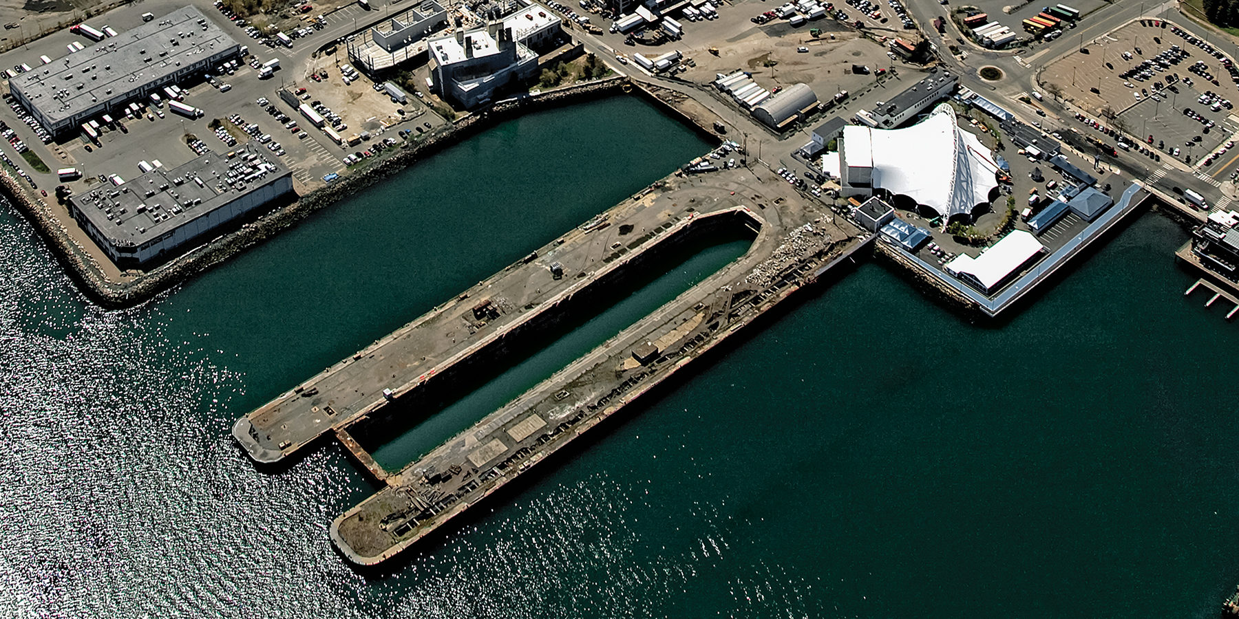
An aerial view of Dry Dock No. 4 photographed in May 2016 by Les Vants Aerial Photos.
In an effort to curate a spectrum of ideas—inspirational, provocative, futuristic—that transforms Dry Dock No. 4 into a signature park, ArchitectureBoston invited a range of firms and artists to the drawing board.
Could they conjure aerial overviews and street-view close-ups that capture their particular spheres of interest while providing creative public access to the water, we wondered? Might there be unexpected avenues for pedestrians to approach this 6-acre landscape—set behind the Blue Hills Bank Pavilion on Northern Avenue—while creating an open-space statement in the Seaport? Is there some way to acknowledge its role as a functioning dry dock, contemplate resiliency efforts, and pay homage to the harbor’s history? Just imagine the possibilities.
PLUG and PLAY
by Lemon Brooke Jennifer Brooke and Christian Lemon ASLA
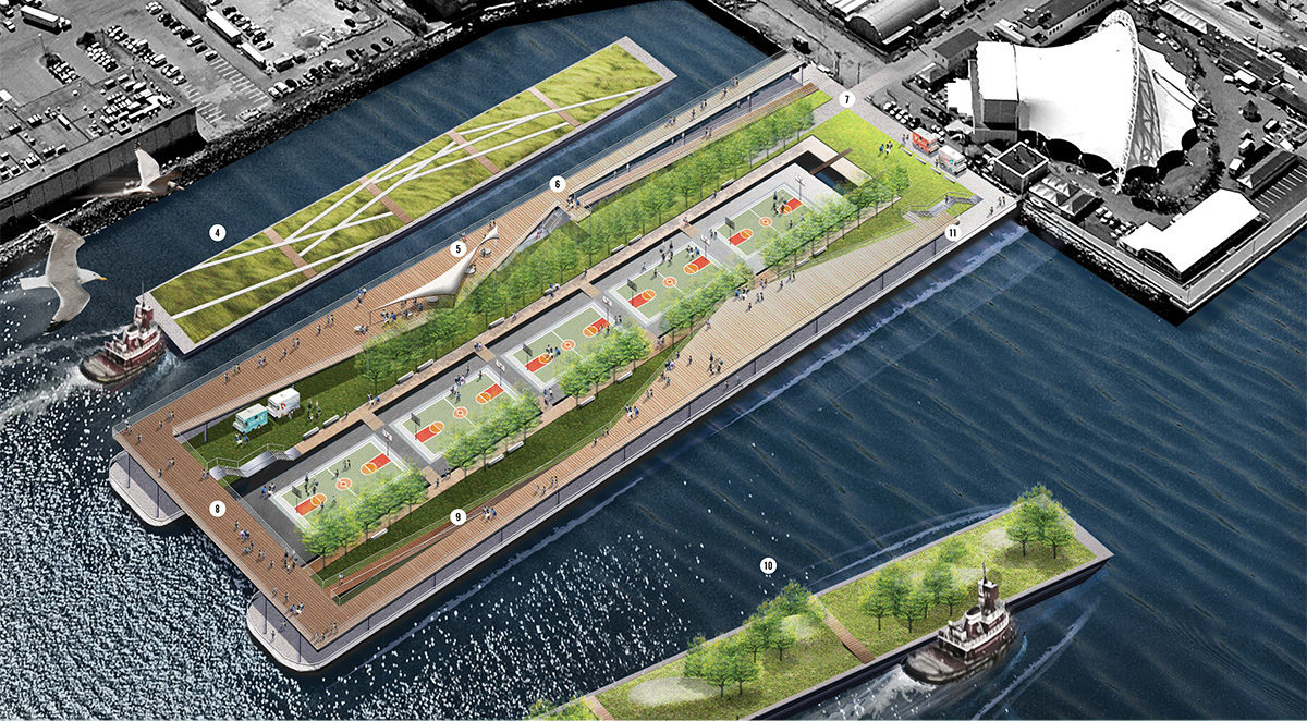
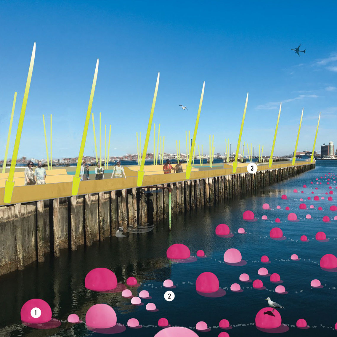
A rusty relic alongside the gleaming new South Boston Seaport developments, the decaying hulk of Dry Dock No. 4 is a visceral reminder of the early-20th-century industrial urban edge, where large ships would visit, conduct business, and then leave. PLUG and PLAY is a park proposal that addresses this dynamic and historic function of the site as well as the recent and glaring revelations that this city district is neither socially diverse nor insulated from the ravages of Mother Nature. At the heart of this park are floating landscape barges that are interchangeable as well as usable along other waterfront sites in the city—A Kit of Parts. The dock, which has been reimagined as an urban green and promenade, serves as a permanent anchor, a link to the shore.
Key to imagery:
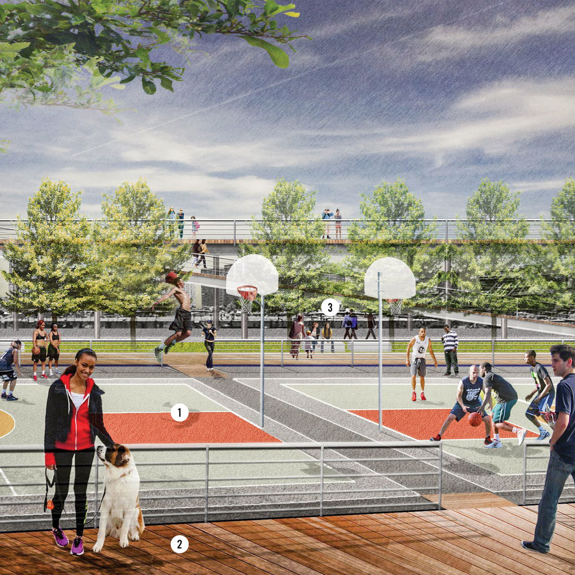
1. Floating venues: The Basketball Barge hosts tournaments and friendly, competitive sporting events as long as the weather permits. With sneakers and a ball, anyone can play, and Bostonians come from all over the city to watch people become players.
2. Change it up: Places of public gathering and recreation, the Barges can be floated to other parts of the city and docked where desired or needed. Their arrival and departure schedule is posted at the Dry Dock No. 4 website.
3. Occupy Boston: Occupiable in a multiplicity of ways, the park accommodates those attention seekers at the center, quite literally, as well as those who prefer views from the more anonymous periphery of the dock edge. The middle ground is most popular.
4. Barge-in-waiting no. 1: Other barges patiently but productively await their turn to plug in. The Salt Marsh Barge offers avian habitat, hands-on educational opportunities and, like a pool filter, is constantly working as it floats around the bay.
5. Seaside stage: The promenade supports light retail with kiosks and a café, making it a place for both actors and an audience. The real show is on the barge below. Lean against the rail, and watch a different barge carefully pull in and slowly populate with denizens of the city.
6. Dock of the bay: The dock is sturdy, industrial, and bulky. The public promenade hovers above it and offers an entirely pedestrian experience, free from the imposition of scale and materials, yet born of it. Stunning views of the bay are here.
7. Public service: A public space for the modern city, Dry Dock No. 4 is a park with a schedule and a social media page. It reinvents the neighborhood every time a different barge docks and injects new ingredients into the soon-to-be extraordinary soup that is the Seaport.
8. Bridge view: The bridge, a pedestrian connection across the dock, is an excellent place to be when one barge is pulling out and another is pulling in. High above the floating landscapes, the views in all directions are outstanding and free.
9. All decked out: Long ramps make the promenade accessible for all and are ideal places for viewing the diversity of humanity visiting the park. The marvels of the city can be experienced, too, as though one were on the deck of a ship pulling into port.
10. Barge-in-waiting no. 2: Periphery Park Barge floats here, waiting in the wings, an entirely engineered landscape, complete with familiar rolling hills, park benches, big trees, and lawn that is mowed courtesy of a herd of sheep that is let loose every few weeks.
11. Park and play: Under the boardwalk, out of the sun, the park has plenty of permanent shady and dry places for parking cars and trucks during the annual Dry Dock No. 4 Flea Market, just one of many citywide programs scheduled here.
Chapter 91 and the DPA: The commonwealth is tasked with protecting both the public’s interest in its waterways and existing water-dependent industries. This project maintains the working character of the designated port area and promotes public use exclusively along the water’s edge. Massing: Bounded by Logan flightpath height constraints above, using the naval cofferdam structure below, and serving the needs of both public leisure and industrial efficiency, the site is part human and part machine. Type A: synthetic building and site form emerges within the massing constraints. Tightly controlled marine industrial insulation enables an extroverted and socially optimized public realm: a civic industrial type.
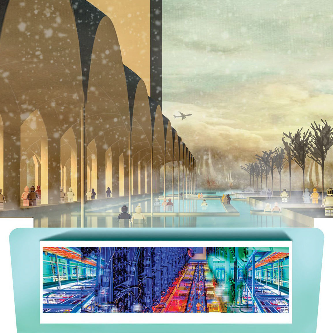
The marine industrial cloud
by Supernormal Elizabeth Christoforetti, Will Cohen, Nathan Fash AIA, and Lauren Matrka
In 2068, machine efficiency has made human labor unnecessary in the Marine Industrial Park. Society has shifted to a universal basic income to equitably and unconditionally distribute unneeded salaries, and Bostonians now pursue human interests in social settings that coexist in parallel with the machine labor that enables them. Given its proximity to the water and the continuing need to use ocean resources, the Marine Industrial Park maintains maritime industrial use as a primary function. While zoning remains unchanged, the efficiency of robotic labor liberates ground levels with the vistas that Bostonians appreciate, both for public leisure and the pursuit of a new form of human work. Dry Dock No. 4 is typical of the building and development types produced by this new economic condition. The stripped-down needs of machine production fundamentally reshape the constraints of building and site design to enable new types of social and civic space.
Key to above Imagery:
1. Agriculture: Resource-efficient food production couples aquaculture and led-lit hydroponic plant cultivation. One million cubic feet of agriculture will produce more than 2 million pounds of lettuce per year.
2. Fish processing: Like the Ford assembly line that preceded it, the low-slung fish hall has sloped floors with typical heights of 4 feet clear to create an efficient line of pollack processing. Cod is extinct.
3. Thermal exchange: Excess heat generated by server farm warms habitable spaces in the building in winter and the public baths year round. Cool harbor waters serve as a heat sink in summer.
4. Information: A server farm resides in the cofferdam in a mediated exchange with cool harbor water, delivering low-latency maritime information processing to the city and offering up excess heat for public good. In the coolest months, 800,000 servers heat baths.
5. Access: Humans visit the site via water. Ferry station becomes part of the Harbor Islands and mbta routes year-round. The abutting interior land is optimized for autonomous vehicle loading and egress toward distribution into the landscape. The edges are for humans, and the interior is for machines. The HarborWalk cuts a path bounded by both uses.
6. Public baths: The carefully controlled heat generated by mechanized marine industrial uses that support Boston create a four-season public space for humans. More than 1 million gallons of water are heated for human use.
7. Program: The automation economy continues apace to support production and human curiosity. The dry dock, which maintains a primarily industrial use, is housed in a building above public baths. Fish is transported from boat to building via drone.
8. The upside down: Seen from below, the “fish-eye” illustrated view best shows the primary role of human occupation, supported and sandwiched by machine uses to insulate human leisure through four seasons.
Aquadock
by Carolina Aragón ASLA
This proposal imagines the Dry Dock No. 4 as a park inspired by the permeable, productive, and rich marshland of the original Boston shore. The design conceptually and physically blurs the boundary between dock and ocean, allowing water in and expanding its adjacent water surface. The ideas set forth speculate how to engage the ocean in ways that harness its potential for energy and food production while creating a unique public space environment. The design imagines retrofitting the existing central basin to create a series of tidal reservoirs for energy production and public recreation. Ocean vertical farming along the edge of the dry dock is an opportunity to create sustainable food production and engage the public with “floating art” from illuminated colored buoys. Eelgrass-inspired lighting serves as a reminder of the natural shoreline.
Key to imagery:
1. “Floating art” Temporary art installations using colored illuminated buoys installed within the existing aquaculture infrastructure make the park visible from adjacent shore locations and airplanes during takeoff and landing.
2. Ocean aquaculture: Sustainable ocean farming for seaweed and shellfish along vertical columns suspended from buoys. This system requires no fertilizers, freshwater, or antibiotics; it sequesters nitrogen runoff and helps reestablish reef ecosystems.
3. Eelgrass lighting: Iconic lighting inspired by the local eelgrass, a marine seagrass commonly found in estuarine settings.
4. Water walls: The reservoir will spill into a second pool along three water walls. The water drop will provide additional hydroelectric power. Terraces for public uses will be located within the space to provide access to this giant water room.
5. Food pavilions: Space for local food vendors to sell locally harvested shellfish.
6. Ocean swimming pool: A tidal swimming pool will create opportunities for summertime recreation. During the winter, it will be transformed into a skating rink.
7. Amphitheater/beach:Large area for sunbathing, airplane watching, and enjoying the park.
8. Tidal barrage: Ocean water will flow through a barrage, or dam wall, containing turbine generators and fill a tidal reservoir.
9. Tidal reservoir: The tidal reservoir will fill according to the tides, providing a deep pool for multiple uses.
10. Water canals: Small canals transport ocean water during high tide to the ocean swimming pool.
Gray—Blue—Green
by Michelle Crowley Landscape Architecture Michelle Crowley ASLA, Naomi Cottrell ASLA, Jessica Brown ASLA, Thackston Crandall ASLA, Erin McCabe ASLA, and Brooke Warfel
Gray—blue—green is a public park that contrasts microcosms of urban, coastal, and pastoral landscapes. The basin and piers of the existing dry dock organize the landscapes into bands, and each plays with visitors’ relationships to the horizon and waterline. The gray band is at city level and connects to the neighborhood’s sidewalks and streets; a community center at the far end has a green roof from which you can see the harbor and islands. The blue band uses the depth of the former dry dock to lower visitors below sea level and immerse them in the space. The green band uses fill to create constructed drumlins that provide elevated prospects over the site, the harbor, and back to the city. Interspersed throughout each band are opportunities for active and passive recreation in unique settings, creating new life on the harbor.
Key to above imagery:
1. Ferry landing: A ferry landing connects this site to the existing Boston Harbor Cruises network, allowing for commuter and tourist ferries and water taxis.
2. Community center: A building with changing rooms, concessions, after-school activities, summer camp, ferry ticketing, and open rooms. The building has a green roof with an observation deck, allowing for a unique vantage of the harbor.
3. Dry-dock promenade: Tree-lined plazas and walkways provide opportunities for picnics, barbecues, fishing, and people watching along the HarborWalk.
4. Harborside playground: Located at the entrance to the promenade, the harbor-themed playground provides a destination for families and opportunities for interactions between visitors to the pier.
5. Drumlin point: The terminus of the green band has terraced seating, providing views back to the city. A splash pad tucked in to the hills connects the pool area to the hills.
6. Fishing piers | floating docks: Floating docks provide an opportunity for fishing and public landing for small watercraft. Owners of small crafts can make the park a day-trip destination.
7. Constructed drumlins: Coastal vegetation covers hills echoing the glacial forms of the Harbor Islands. Nestled in the landform are opportunities for recreation, habitat, and views. Paths cut through the drumlins, and retaining walls expose the artificiality of the landform.
8. Amphitheater: Nestled into the nose of the basin, the amphitheater provides a public counterpoint to the Blue Hills Bank Pavilion next door, offering access to the coastal wildlife of the blue band and allowing visitors to experience the depth of the dry-dock basin.
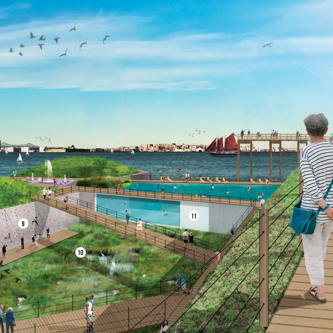
9. Climbing walls - boardwalks: The climbing walls and boardwalks within the basin allow for a close-up experience of the structure of the dock and the unique ecosystem occupying it.
10. Basin salt marsh: A salt marsh constructed inside the basin just above low tide is a familiar habitat in an uncanny location. A lock system controls the flow of water while keeping the whole system lower than a naturally occurring marsh.
11. Aquarium swimming pool: On the harbor’s edge, the natural pool sits among the ships of an active harbor. Clear sides allow parkgoers to watch swimmers and swimmers to watch the ocean life. In winter, the floor rises, creating a skating rink.