Skip to content
Boston Society of Architects

Temporary Feature

Model behavior

To ignite lasting solutions, try small-scale prototypes

Model escr stuyvesant cove dry original light noboats

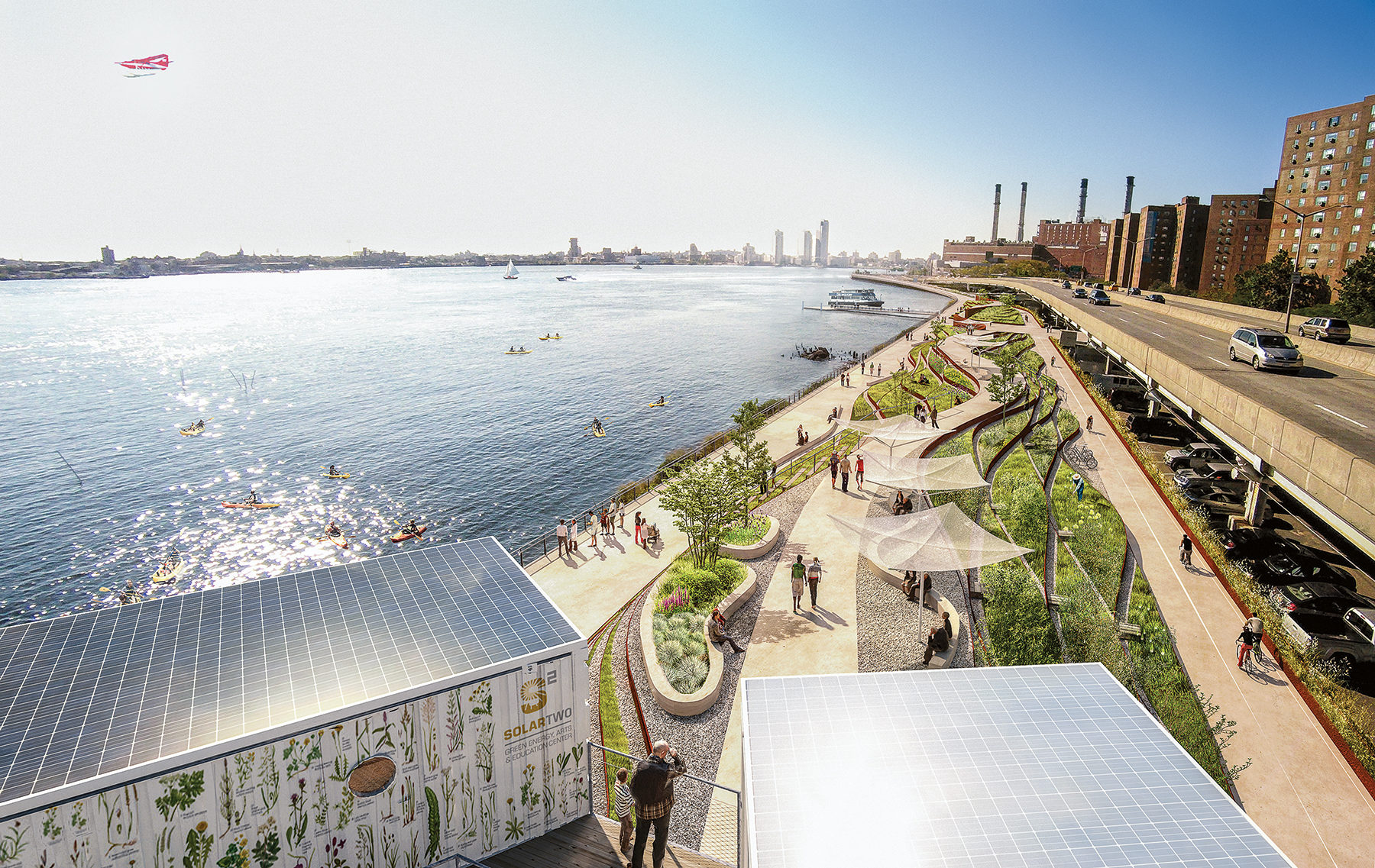
Rendering of the Dryline, designed by the Bjarke Ingels Group (BIG) after Superstorm Sandy, as a multiuse park and waterline buffer for Manhattan.

Image: Courtesy of BIG

Pop-up, temporary, tactical, diy. You cannot scroll through an article about urban design without finding projects that frame the process of city building as participatory, fun, and chock-full of experimentation. Designers, activists, and even developers have taken to the streets, quite literally, to prototype the potential of their cities. In New York City, Times Square has experienced a pedestrianized transformation that began in 2009 with a tactical takeover by the NYC Department of Transportation using lawn chairs. In Boston, the Lawn on D has become the brightly colored, ping-pong table–infused poster child for temporary parks in underused neighborhoods.

Though conceived and implemented as pilot initiatives, these short-term projects have found a home within the tactical urbanism movement. This creative approach to testing temporary, locally based interventions geared toward long-term change has taken root in communities across the globe. The advent of creative placemaking, the maker movement’s tools of digital production, and everyday citizens’ frustration with the often bureaucratic planning process has led to tactical urbanism’s prominence in the urban design dialogue.

Designers have long recognized the influence of a good physical model, which in many ways is what these temporary, low-cost interventions can become. Sensory and interactive, the models invite stakeholders to connect with a future investment, albeit at a smaller scale and with less risk. They show citizens what they’re buying before they write the check. But the tenets of tactical urbanism — quicker, lighter, cheaper — are not limited to temporary solutions.

Indeed, cities are resolving some of their most pressing challenges by using prototypes to inspire broader change. In Raleigh, North Carolina, a guerrilla signage campaign aimed at encouraging people to walk resulted in a new pedestrian plan for the city. In San Francisco, Park(ing) Day catalyzed an international phenomenon, transforming parking spaces into tiny pop-up parks. Cities across the country have since implemented formal programs that encourage cafe and restaurant owners to build permanent parklets in front of their shops.

In New York City, Janette Sadik-Khan, the city’s former Department of Transportation commissioner, wielded pilot testing as her secret weapon. “Instead of arguing and debating, try something first and give people something to experience,” she said in a recent interview with CityLab. “When you adapt a place and adapt a space, people adopt it.” Her proof-of-concept pilots included painted bike lanes and those lawn chairs in Times Square. The efforts led to the transformation of more than 400 miles of the city’s streets, integrating bike lanes, safer pedestrian crossings, and narrowed vehicular travel lanes. New York’s Complete Streets have raised the bar for safer, more attractive, and efficient streets across the United States.

As cities search for solutions to large-scale environmental and societal pressures, tactical urbanism’s can-do, optimistic approach has the potential to galvanize support for long-term strategies well beyond the scale of the parking spot. Citizens and municipalities have difficulty finding common ground on such issues as sea-level rise, drought, and housing shortages. To complicate matters, these issues are occurring at the scale of multiple cities or whole regions, which lack a single entity that can act unilaterally to address them. Pilot projects that embody the “test before you invest” mantra could help synthesize collective visions toward the future.
As Boston undertakes its first masterplanning process in 50 years, the city should harness the power of prototypes to test ideas. Rising seas, soaring housing prices, and underused land are serious issues facing Boston today. But it is not easy for the average citizen to imagine what a resilient coast could look like or what 50,000 new units of housing will mean for their neighborhoods. Because it’s impossible to show what those projects might look like until they are finished in 10 to 30 years, garnering support is tough. Long-range planning at a city scale takes time, political will, money, and community patience. By applying the tenets of tactical urbanism, pilot projects could show the untapped potential of our city sooner rather than later.

Take sea-level rise: Scientists project that Boston’s tides will rise 2 feet by midcentury and 6 feet by 2100. This new tide line will transform the city’s urban landscape and increase the probability of a major storm devastating the metropolitan region. After Superstorm Sandy narrowly missed Boston, the city has led the charge to be a model resilient coastal community. The Living with Water competition, sponsored by the city with The Boston Harbor Association, the Boston Redevelopment Authority, and the Boston Society of Architects /AIA, gave designers a platform to paint optimistic visions for our new wet future. Concept renderings showed raised sidewalks, floating buildings, and protective wetlands. But ask the average citizen what it means to build a resilient coast, and you’ll often be met with blank stares. Prototypes show what is possible, which is imperative in the lead-up to making real changes to the way we plan and build in Boston.

One of the most successful projects to emerge from Rebuild by Design, the U.S. Department of Housing and Urban Development’s resiliency competition for communities affected by Superstorm Sandy, was Bjarke Ingels Group’s Dryline, a multifunctional seawall that aims to protect the lower tip of Manhattan while providing creative recreational and cultural amenities. Think seawall + benches + community spaces + farmers market stalls. One of the principles of resilient design is ensuring multiple uses for any given investment. Today’s seawalls serve only one purpose: to keep the water out. Given the lack of valuable space in Boston, coupled with the need for better protective measures, our coastal edges should serve more than one role. Boston could pilot creative ideas for multifunctional seawalls before investing millions in storm surge infrastructure. Imagine a segment of an existing seawall in the Seaport District transformed to include seating, animal habitats, or recreational features such as a climbing wall at low tide. The existing seawall would provide necessary protection, while a series of newly designed temporary façades could illuminate the possibilities for multifunctional infrastructure.

Tactical urbanism shows citizens what they’re buying before they write the check.

Or imagine the Boston Harbor Islands transformed into a testing ground for a variety of resilient coastal strategies. An island could become a research hub for experimenting with new edge conditions, where we could document and quantify the protective effects of dunes, saltwater marshes, seawalls, or small flood gates. The temporary takeover of one or more islands could demonstrate the potential of innovative shoreline structures or plantings that could then be applied across the city. A partnership of this kind between the National Park Service and the city could serve multiple goals, inspiring and featuring the work of local designers and ecologists, educating citizens, and positioning Boston as a world leader in resilient construction and adaptation.

What about Boston’s housing crisis? The Imagine Boston 2030 engagement campaign has confirmed that affordable housing is one of Bostonians’ top concerns. The city’s housing efforts could be helped by experimenting with new land-use relationships in underused neighborhoods. Envision land currently zoned for industry in the Seaport or East Boston populated with new prefabricated workforce housing.

The city also could experiment with a new land-use model that could lead to a better mix of low-density industrial use with higher-density residential use. Existing one- to two-story warehouses could be intermixed with temporary buildings placed on vacant industrial land. The structures could provide space for storefronts, apartments, and offices. In London’s Shoreditch neighborhood, the temporary outdoor shopping district BOXPARK emerged from pop-up shops housed within 60 connected shipping containers. Similarly cost-effective prefab housing could demonstrate the potential of mixed-use zoning and grease the wheels for denser, more affordable neighborhoods that encourage 21st-century industrial uses such as maker spaces, fabrication studios, breweries, or indoor urban agriculture. Diverse industries could provide local jobs to Boston’s neighborhoods while housing could create walkable transit-oriented communities, reducing traffic and sprawl. An affordable pop-up neighborhood, as a first step in redevelopment, could generate momentum around a new district and gauge interest in experimental housing typologies.

Boston is in the midst of a critical process that will inspire the development of the city for the next several decades. As a planning and design tool, tactical urbanism has proven effective in generating short-term action around long-term change, but it doesn’t absolve those of us at the helm of city planning and design from committing to rigor, political process, and public investment. Where traditional planning approaches — so often opaque and abstract — fail to ignite public passions, tactical urbanism can add a dose of accessibility, whimsy, and imagination. Designers, city officials, community members all can engage with prototypes, creating a dialogue around what works and what does not. By harnessing the power of the prototype, Boston can show, not just tell, what’s possible for our city’s future.

Related