I’m sure I’m not the first person to return from a trip to Europe with a fresh perspective on urban life. But having recently traversed Copenhagen, Denmark, I’ve begun rethinking the role of Boston’s streets. The city’s fabulous organic street grid is similar to those in Europe that were built around walking, horse carriages, and the proverbial conversion of “cow paths” into modern streets. Boston’s crooked streets, like those of many medieval town centers, have served to make it one of the nation’s most walkable cities, but compared to Copenhagen, it remains remarkably focused on automobile traffic.
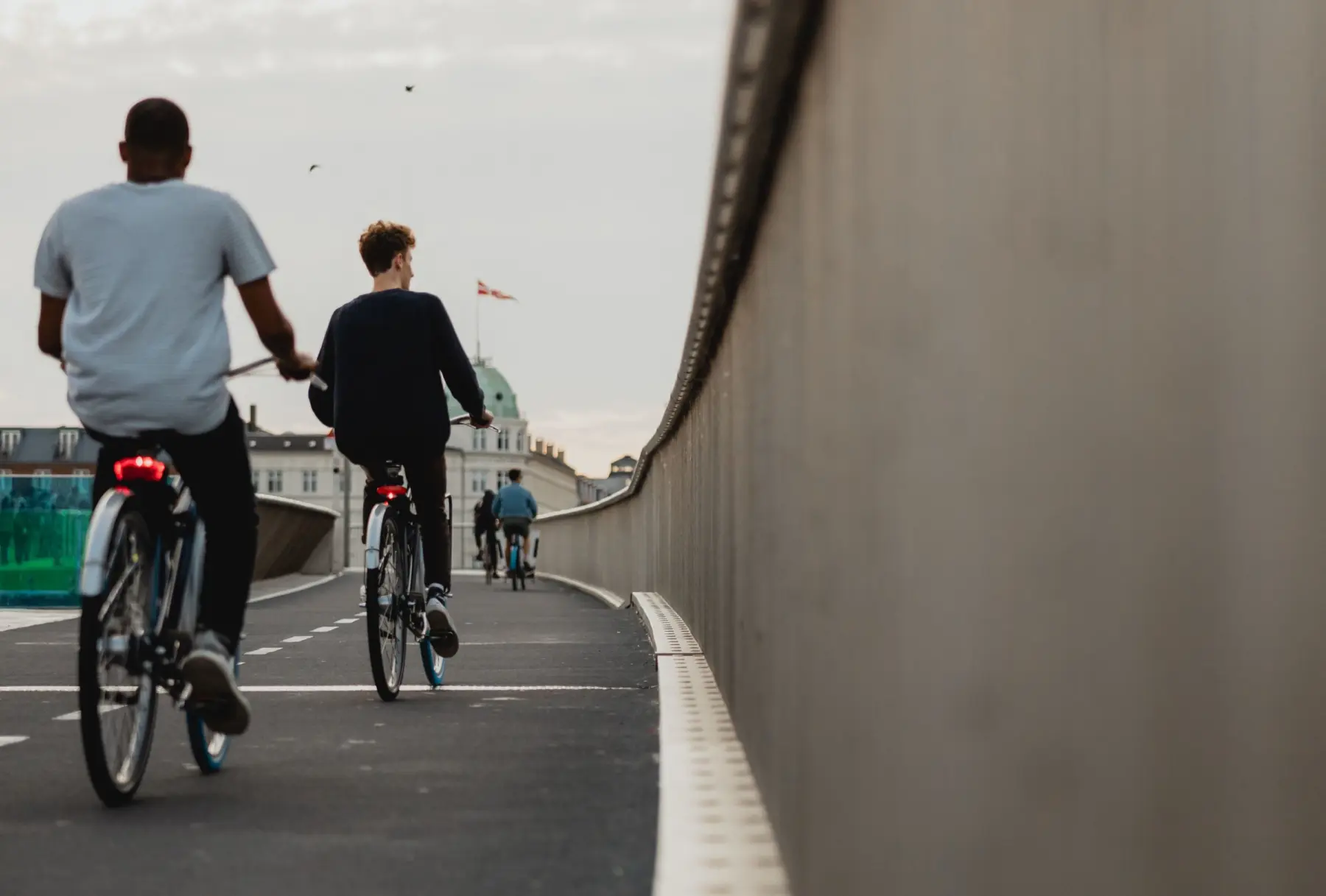
Starting in the 1970s, interest in cycling in Copenhagen began to increase. Bicycles now outnumber cars.
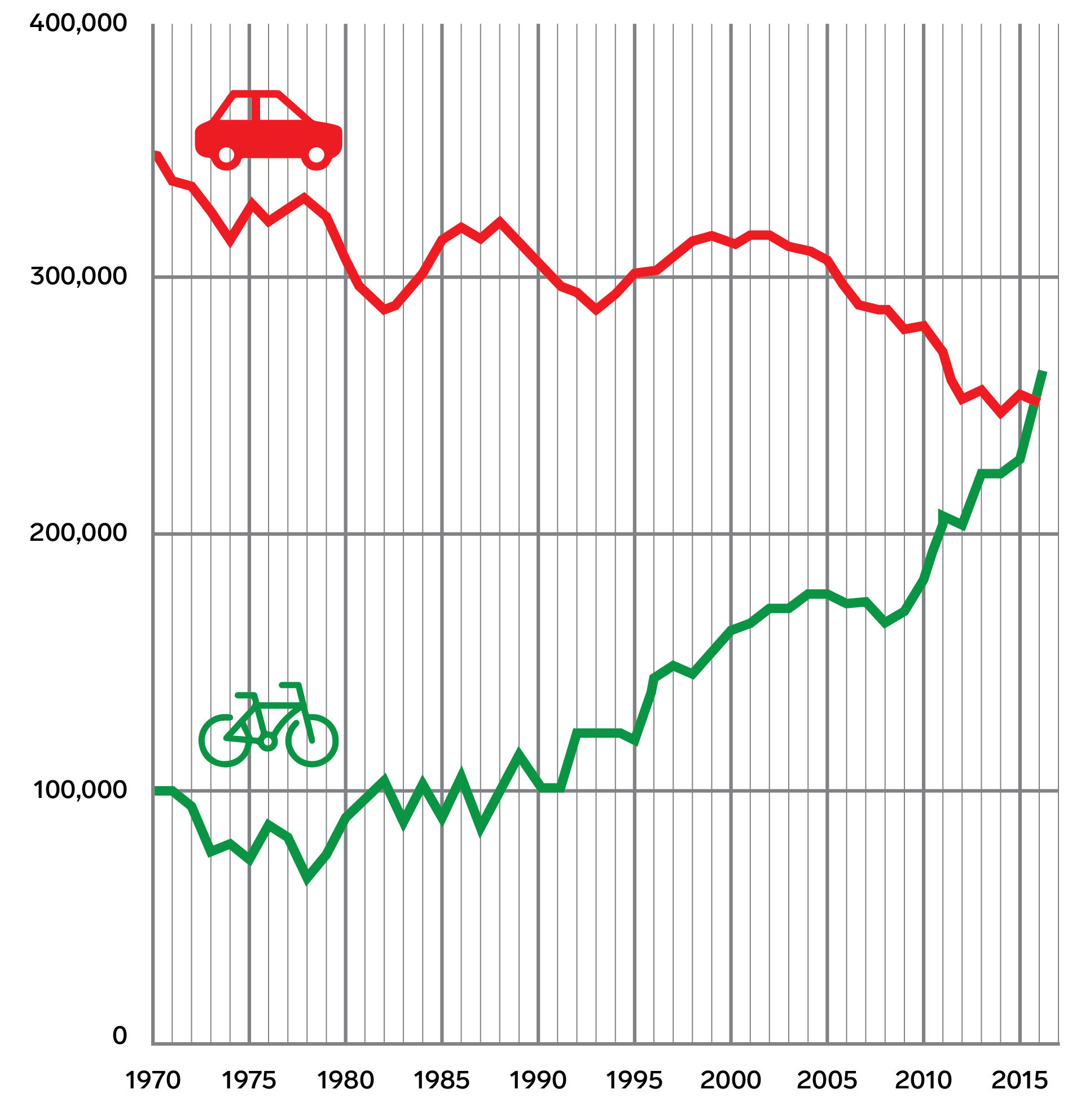
Copenhagen was not always a mecca for cyclists. After a long history leading up to and including the Second World War, when cycling was the dominant form of transportation, cycling in Denmark declined after increased prosperity saw an uptick in automobile usage. Danish urban planners—like other planners around the world—built urban expressways through poor neighborhoods and expanded lanes for cars to improve traffic flow. The result was a precipitous decline in cycling to less than 20 percent of travel in the late 1950s and 1960s.
The energy crisis of the early 1970s saw a reversal of this decline, and the introduction of Car Free Sundays in Copenhagen—to save fuel—was so popular that it sparked a movement to restore cycling as a serious mode of travel. Since the 1960s, Copenhagen has constructed about 250 miles of cycle paths separated from car lanes and sidewalks. Bicycles outnumber cars 7-to-1; a 2016 survey counted 267,700 daily bike trips compared with 252,600 for cars.
Despite modest progress, Boston is still many years behind Copenhagen in adapting its streets to uses other than for private vehicles: Washington Street and Summer Street as pedestrian promenades that largely exclude traffic; bus-lane experiments to improve flow during rush hours; bike lanes and Commonwealth Avenue’s newly completed off-road bikeway.
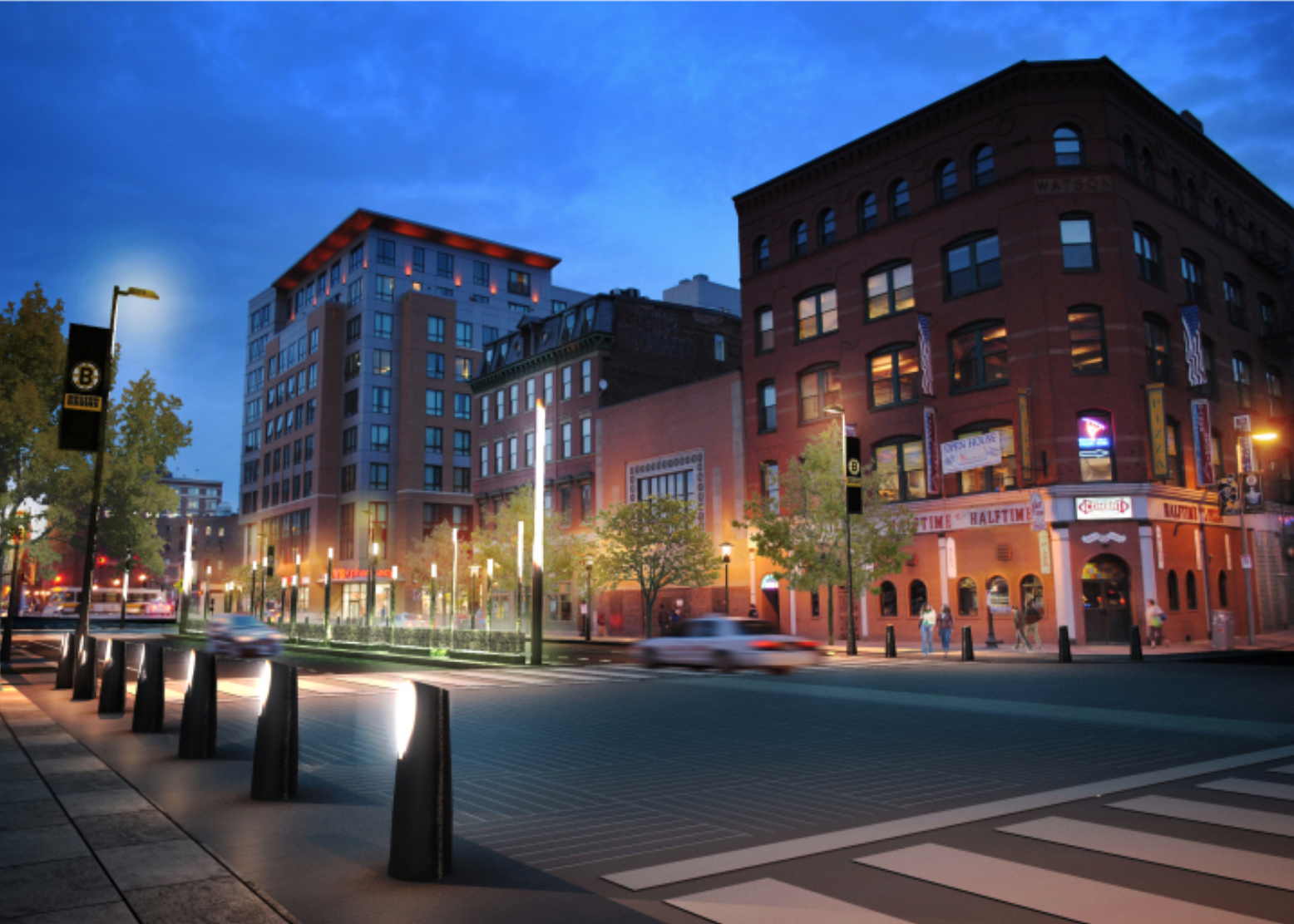
One illustration of Boston’s evolutionary thinking in roadway design can be found on Causeway Street. In 2007, Boston was beginning its Crossroads program, intended to reknit the city across the newly built Rose F. Fitzgerald Kennedy Greenway with pedestrian-friendly corridors. The staff at the Boston Redevelopment Authority (now called the Boston Planning & Development Agency) and a consultant team I was leading envisioned Causeway Street at North Station looking much like Dewey Square at South Station—where nearly 100,000 daily transit riders swarm the plaza every morning and evening.
Even though North Station has fewer riders than South Station, the station puts no less of a strain on Causeway Street during rush hours. We pictured Causeway Street as a gateway to welcome commuters entering and leaving the station, and improve the retail experience along the narrow sidewalks. But halfway through the design phase, the City received federal funding for the Connect Historic Boston Trail, which envisioned an off-street bike loop circling downtown and running the length of Causeway Street to connect the North End with Beacon Hill. The utilitarian result, built in 2014, is a two-way bike lane oddly running down the middle of the road without access to the stores or amenities along the street edges. Nor is there much in the way of aesthetic improvements or areas for landscape treatments.
Cyclist POV in Copenhagen
Cyclist POV riding down an urban road in Copenhagen, Denmark. Video by piola666 on iStock.
At the time, the design community I spoke to was disappointed that the implementation of the Connect Historic Boston Trail had precluded the chance for Causeway Street to be a more beautiful gateway to the city. Today, The Hub on Causeway, a mixed-used development, is finally nearing completion, with the recent opening of a Star Market in September. Could the street yet again be up for rethinking as a gateway as well as a bike corridor? Ten years later, what would we build, and would it be different this time?
Causeway Street came to mind on my recent trip to Denmark. Much like Causeway, the generous bike lanes in Copenhagen, while providing some of the safest streets for cyclists, come at great cost to other amenities within the public realm. For example, few of the roads in this famously bike-friendly city have any street trees, and pedestrian sidewalk widths are narrow, some might say minimal, often forcing pedestrians to travel single-file past parked bicycles and outdoor seating. On-street parking is likewise absent on main thoroughfares. So, while Copenhagen is graced with fine and colorful architecture—which goes a long way to ameliorate the loss of trees—the dominant gray of asphalt, the relative space allocated to the various forms of mobility, and the lack of aesthetics speak to a rather single-minded optimization for ways to get around, with cyclists generally the largest users of street space.
Causeway Street rendering. Courtesy of NBBJ.
Would Bostonians agree to such a bargain if it meant narrower sidewalks and the loss of landscaped areas throughout the city? Given the emerging green agenda—the desire to reduce heat islands and treat stormwater flows—a new range of priorities is emerging in Boston for the limited amounts of public rights of way. Another contender is the seemingly endless space needed for Uber and Lyft vehicles that perpetually clog travel lanes while they drop off or pick up passengers. Parcel deliveries from online shopping are also increasing: New York City, for example, recently reported that more than 1.5 million packages are delivered each day, clogging roadways with double-parked trucks.
Cyclist POV Commonwealth Avenue, Boston
Video by Luke Leissring
Copenhagen has doubled down on the bike, and the results are spectacular in terms of reducing vehicle use within the city and therefore its carbon footprint—it is on target to be carbon neutral by 2025. Although Boston has made modest progress toward improving alternative forms of mobility, the facts are not encouraging: Between 2012 and 2017, the population in Boston grew by 7 percent, but household vehicle ownership in Boston rose by 15 percent. While some of this increase may be a result of off-street parking lots constructed as part of new housing developments, on-street parking remains a nearly sacred right in some of our most crowded and historic neighborhoods. In many of these neighborhoods without access to reliable transit—Dorchester, for example—it is painstakingly difficult to remove parking from streets in order to make room for bike lanes, bus lanes, or green spaces.
In Boston’s diverse neighborhoods, notions of a “complete street” may vary. Boston has complete-streets guidelines that attempt to balance the needs of drivers, cyclists, and pedestrians. But our narrow streets often demand prioritizing between an even wider set of goals. Advocates have competing priorities not only for street space but also for public funds that are needed to rebuild streets. Right now Boston and the Commonwealth have a host of challenges to address; how important is carbon reduction relative to an affordable-housing crisis or a failing transit system or sea-level rise?
Bike Lanes on Comm Ave
Courtesy of BU Today/Boston University
Ultimately, recalibrating our streets is dependent on discussions far beyond a complete-streets manual. For example, a functioning transit system is essential to provide an adequate alternative to the private car. Despite the claims made by transit-network companies—Lyft, Uber—car ownership and traffic volumes continue to rise, at least in Boston. In the absence of an efficient rapid-transit backbone, can we downsize vehicle lanes without a serious backlash? Adequate transit can bring down car ownership rates and free up street space for other uses (and also lower the cost of housing). Only once an efficient transit system is in place can our streets be reconsidered for these other priorities: bikeways, sidewalk cafés, rain gardens, shade trees, or curb drop-off spaces for ride-share and delivery vehicles.
Sharing the road means first understanding what types of mobility we want to prioritize. Then we need to fund our infrastructure in order to achieve a Boston street that may look different from one in Copenhagen, but one that will reflect our values as Bostonians.